
by Theja Putta, who just completed his PhD under Peter Furth’s supervision.
I have been commuting to Northeastern for several years on my bike. While most of my ride is on the Southwest Corridor bike path, the last section of my commute involves riding the wrong way on a one-way street (Leon Street). I regularly see other bicycle commuters going the wrong way on Leon Street. The alternatives are to walk my bike on the sidewalk or ride on a longer and stressful route. The Boston area has many other quiet one-way streets that also see regular wrong way riding. Anecdotally, this shows the critical role played by riding the wrong way on one-way streets in enabling people to ride safely and efficiently to their destinations. We set out to determine, scientifically and systematically, the degree to which one-way restrictions create a barrier to low-stress bicycling in greater Boston, and how much of that could be alleviated by allowing cyclists to ride the wrong way legally on certain streets, a practice called “bicycle contraflow.”
It is within the power of a city to designate one-way restrictions on its street. Cities can make “bicycle contraflow” legal by stipulating that bicycles are exempt from the one-way restriction on any given street. At this time, Cambridge, Somerville, and Brookline each have a handful of segments with bicycle contraflow; Boston has just one. Cities with more widespread use of contraflow, mostly in Belgium, Netherlands, Germany, and France, have found that contraflow on local streets improves safety – partly because it improves predictability (even without contraflow, some cyclists will ride the wrong way) and partly because it allows cyclists to follow quieter, safer streets than they would have to follow if they obeyed one-way restrictions.
We conducted a study to determine the negative effect of one-way restrictions on low-stress bike network connectivity in Boston, Brookline, Cambridge, and Somerville. Our method was to determine, for each home, how many jobs in those four municipalities one could reach using only low-stress streets — because most people are not willing to ride on high stress segments — and obeying one-way restrictions. A street was considered low-stress if it had Level of Traffic Stress 2 or 1 based on Furth’s LTS criteria; to simplify, one can say that most local streets, all streets with protected bike lanes, and some streets with conventional bike lane are low stress. A job was considered accessible to a home if there was a low-stress route from the home to the job and back again without a long detour. Population and job data were obtained from the U.S. Census. This analysis allowed us to determine not only what the overall accessibility is, but also to map which areas have better or worse accessibility, and which areas would see the greatest gain in accessibility from allowing contraflow.
[Here’s the detail on how detour was accounted for. For any home-work pair, detour factor was measured as a ratio of length of the low-stress path the the length of shortest path that uses both low- and high-stress links. We considered jobs with a detour factor less than 1.2 to be fully accessible and those with a detour factor of more than 2 to be inaccessible. Jobs with a detour factor between 1.2 and 2, they were considered partially accessible using a linear scale ranging from 100% accessible (when the detour factor is 1.2) to 0% accessible (when the detour factor is 2.0). For example, consider a low-stress route connecting to a site with 100 jobs. If the detour is less than 1.2, all 100 jobs are considered accessible; if the detour factor is 1.4, then 75 jobs are considered accessible; if the detour factor is 1.6, then 50 jobs are considered accessible, and so forth.]
Our analysis showed that currently, homes have, on average, just under 8000 jobs accessible using the low-stress bike network, which comes to just over 1% of the total jobs in the area. This result is a reflection of the poorly connected bike network in the Boston area (which is constantly improving), particularly around job centers such as downtown and in the Longwood Medical Area. If bikes are allowed to ride contraflow on all local streets, the number of bike-accessible jobs per home increases to 68,000, an eight-fold increase in accessibility. This improvement is not uniform across the study area; areas with a lot of one-way streets like Dorchester and Somerville realize larger benefits than others. Many homes in Dorchester and Roxbury that currently have access to less than 1000 jobs would have access to over 100,000 jobs, a more than 100-fold increase in accessibility. Many homes in Roslindale, West Roxbury, Hyde Park, and Somerville that now have access to 10,000 or fewer jobs would have access to over 100,000 jobs. Even neighborhoods whose current bike access to jobs is good relative to the rest of the metro area, including Fenway-Kenmore and Kendall Square, would realize large gains in access to jobs with local street contraflow.

Accessibility to jobs with and without local contraflow
This result is from a test allowing contraflow on all local neighborhood streets; wrong-way riding was still prohibited on arterial one-way streets, such as Stuart Street in Boston’s theater district. Local streets, with their slow and infrequent traffic, are ideal for contraflow application. The conflicts between bicyclists and drivers are infrequent, and encounters are at a slow speed and with full visibility, making them safe. In many European countries like Netherlands, France, and Belgium, virtually all local one-ways allow contraflow. Studies in countries that have systematically implemented contraflow across their networks found that contraflow on local streets does not create unsafe conditions. On the contrary, the overall safety in the network improved due to contraflow, because it allows people to use quiet, local streets instead of more dangerous parallel arterial.
In the Boston area, only a few streets currently allow bicycle contraflow (see Boston Area Contraflow Map). Out of 324 miles of local one-way streets in the four municipalities studied, there are currently 1.7 miles of contraflow. There is an additional 0.6 mile of contraflow on non-local one-ways, out of 86 miles.
Some historical context is warranted. Almost no local street anywhere in the world was built to be one-way. One-way restrictions came later, mostly in the 1960s and 70s, for the convenience of auto users, to make it possible for people to park on both sides of a narrow street without creating traffic jams. In Belgium and France, the movement to legalize bicycle contraflow (in the 1990’s and early 2000’s) was based largely on equity, to undo the harm done to bicycling — and to people who can afford a bike, but not a car– by making streets one-way in the 1970’s. Our study shows that, just as in Europe, the widespread application of one-way restrictions on local streets in the Boston area has done substantial harm to bicycling.
A second reason one-way restrictions have sometimes been applied to local streets is to prevent through traffic from using neighborhood streets. In Boston’s South End, for example, there are several one-way streets whose direction reverses at critical points, making it impossible to go through in a car. Nobody ever intended for those restrictions to keep out bikes, but that’s been the unintended consequence. It’s especially ironic because those one-way restrictions, by keeping through traffic out, make those streets ideal for riding a bike — except that without contraflow, it’s illegal. In Somerville, Hancock Street has long had this kind of reversing one-way restriction, to keep through traffic from using it. Since the city legalized bike contraflow there in 2017, hundreds of cyclists a day now get to enjoy riding on a quiet, safe street that cuts across town efficiently yet keeps through traffic out.
Is contraflow important only in poorly connected bike networks such as we have today, or will it also be important in the future as we develop a more robust bicycling network? To test this, we measured home-to-job accessibility using a proposed, well-connected network called Bikeways for Everybody, proposed by the Boston Cyclists Union. In this proposed network, nearly every arterial has protected bike lanes. Compared to what we have to today, bike accessibility to jobs is vastly better – the average home would be accessible to 64% of the jobs in the area. However, this accessibility goes up to 80% if we also allow local street contraflow. This shows that even with a vastly improved bike network, Boston and surrounding communities still need contraflow for people to have good bike accessibility to jobs and other destinations.
We also wanted to determine, from a network point of view, which one-way streets are the most critical barriers – or, conversely, which links would offer the greatest connectivity benefit if they were converted to contraflow? We created a metric for how valuable contraflow would be on a given road segment, called “change in potential flow;” it’s the difference in the potential flow of bicycles on a road segment in a network with contraflow allowed on all local streets versus in a network without contraflow. (“Potential flow,” called “centrality” in graph theory, is the bicyclist volume that would occur if everybody rode a bike to every job they could reach.) Out of the 324 miles of local one-way streets in the 4 communities we studied, if only the 10 miles with the highest change in potential flow were converted to contraflow, jobs accessibility to the average home would go up fourfold. That represents about 50% of the gain that would occur if ALL local streets were converted. The map below shows these critical streets in red; to name a few of them, they include:
- In Somerville: Calvin St, Harvard St, and Hudson St
- In Brookline: Ivy St, Essex St, and Lenox St
- In Fenway-Kenmore: Allston St, and Hancock St in Cambridge; Miner St, Van Ness St, Jersey St, and Leon Street
- In Roxbury: Oakland St, Dale St, Clifford St, and Julian St
- In Jamaica Plain: Carolina Ave and Custer St
- In West Roxbury: South Fairview St
- In Dorchester: Hamilton St and Draper St.
(The first two Brookline streets listed already have legal contraflow, but are shown to emphasize their importance.)
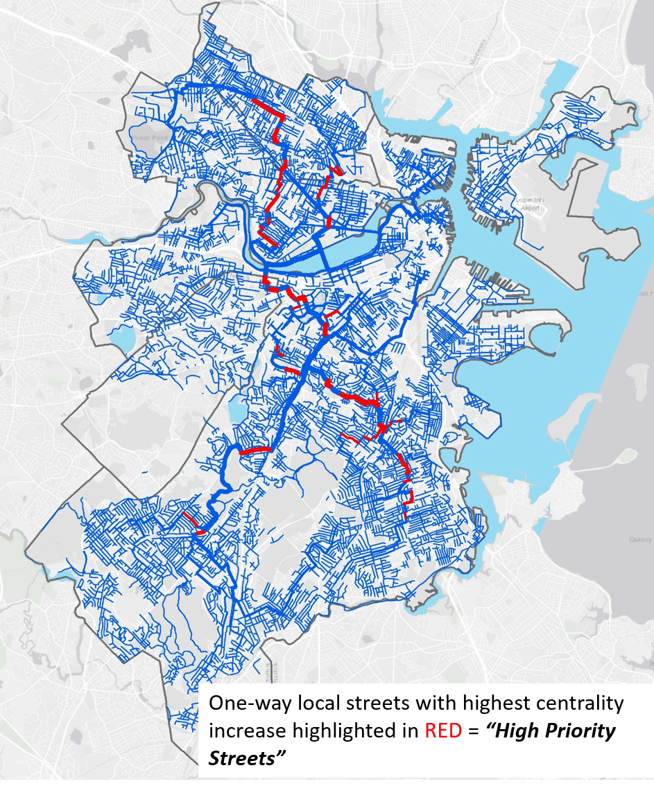
Increase in centrality (potential flow of bikes), when contraflow is applied to local streets, is indicated by line thickness. Segments in red are one-way streets with high increase in centrality, meaning they are the most critical for achieving connectivity gains using contraflow.
The previous map shows, by line thickness, the increase in potential flow on every segment due to allowing contraflow on all local streets. Some of these segments are two-way streets and paths, which will carry more people as contraflow makes it possible for more people to reach the bike network. The one-way streets with increased potential flow can be divided into two groups. Those with relatively small increases (thin lines) are important for the people living on them or very close by, enabling them to get to the bike network. Those with thick lines — if they are one-way segments, the thick lines have been recolored red — are important not only to immediate neighbors, but also become important routes in the bike network in their own right.
Bike routes that mostly follow local streets are known variously as local street bikeways, bike boulevards, neighborhood greenways, and neighborways, and have proven to be an extremely effective, popular, and inexpensive way of expanding the bike network in cities including Berkeley, Portland, and Vancouver BC. Boston’s transportation plan, too, recognizes the importance of ‘neighborways’. However, Boston currently has no real neighborways to speak of, and the simple fact is that, because of the prevalence of one-way restrictions on local streets, neighborways are simply not feasible here without using contraflow. Hancock Street in Somerville and Essex-Ivy Streets in Brookline are two of the Boston area’s few examples of main bike routes following local streets. Both use one-way restrictions to keep through traffic out, and both use bicycle contraflow to make them legitimate bike routes.
Our study looked at access to jobs, but similar results are expected for other trip purposes such as getting to grocery stores or school. For local trips, such as those to supermarkets, playgrounds, and libraries, it isn’t enough to apply contraflow to a few miles of local streets; widespread implementation is needed so that people can easily bike on the shortest path using quiet, local streets.
In Belgium, France, and Netherlands, contraflow is not at all controversial; rather, it’s ubiquitous. In the Boston area, however, it remains controversial. This study helps show why contraflow is needed: to improve bike accessibility to jobs and other destinations, to undo the harm done to bicycling by making local streets one-way, and to make it possible for cities to develop safe, attractive, and inexpensive ‘neighborway’ routes for bicycling.
For more detail, see Theja Putta’s PhD Dissertation, “Evaluating Bicycle Networks: Visualizing And Measuring Low-stress Connectivity And Accessibility”, 2019. Peter Furth was the dissertation advisor. This research was generously supported by the Helen and William Mazer Foundation.