
Providing a protected bike lane, or cycle track, along “Mass Ave South” — that is, Mass. Ave. from Melnea Cass Blvd to Columbia Rd (Edward Everett Square) is critical for Boston’s bike network. This creates a traffic engineering challenge — how to find the space for a cycle track? At the railroad underpass just south of the intersection with Newmarket Square and Shirley Street, Mass Ave is just wide enough for 4 lanes and a pair of sidewalks. Is it possible to reconfigure that intersection with only 3 lanes for Mass Ave on the southern leg (i.e., at the railroad underpass), while carrying all the traffic the street carries today? That’s the design challenge this project addresses.
1. Existing Situation
1.1 Layout and Timing Plan:
The intersection of Mass Ave @ Shirley St/Newmarket Sq is currently a dog-leg intersection, with the Shirley St and Newmarket Sq legs slightly offset from one another (Figure 1). The signal cycle length is 100 seconds and all turning movements are allowed. Mass Ave, known in this project as the north-south street, has permitted lefts for both NB and SB movements, but Shirley St / Newmarket Sq has split phasing, that is, one distinct phase for each street. The sequence is that the Mass Ave phase (NB and SB simultaneously) is followed by Newmarket Sq (WB), and then by Shirley St (EB), then returning to Mass Ave (N-S). The N-S phase begins with a 4-second leading pedestrian interval (LPI). Right turn on red is allowed for both EBR and WBR movements, and a protected NBR phase runs concurrently with WB phase. The control along Mass Ave is coordinated, meaning the cycle length is fixed. The WB/EB approaches are actuated. On both actuated legs, 50-ft stopline detectors are used as both call detectors and extension detectors. The only crosswalks across Mass Ave is a diagonal crossing, as shown in Figure 1 below; due to the offset of Shirley St and Newmarket Sq, it is relatively direct. Crosswalk lengths are as shown in Figure 1.

Figure 1 – Existing Layout of Mass Ave @ Shirley St/Newmarket Sq Intersection
A general knowledge of traffic in the area suggests that the PM peak is the most congested period, and so it was studied. Turning movement counts were made on a weekday afternoon in Spring, 2019 between 4:00 to 5:15. The peak hour period was found to be from 4:00 to 5:00 pm. Peak hour counts are given in Figure 2.
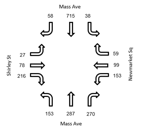
Figure 2 – PM Peak Counts for Mass Ave @ Shirley St/Newmarket Sq Intersection
1.2 Observations of the Current Operation
Several issues already exist at this intersection:
- During the PM peak, NBL and SBL vehicles advance halfway through the intersection and wait almost for the entire green period for a gap. They typically cannot find the gap of desirable length until after opposing through movement’s green time. So, the majority of these vehicles complete their turn as “sneakers,” during the latter part of the yellow and the red clearance time. As they wait, they have significant blockage effect on through traffic along Mass Ave., shutting down flow in the left lane for a substantial part of the green interval.
- The mentioned left turns frequently interlock, due to the intersection offset; the resulting blockage often lasts longer than the red clearance period. Therefore, when WB the movement is released, the intersection is still occupied by left-turning vehicles from the Mass Ave phase. That means that the way left-turners are inadequately served not only engenders capacity loss along Mass Ave, but also for the Newmarket Sq approach as well.
- To compensate the blockage effect described earlier, the red clearance intervals are unusually long. Red clearance intervals after NB/SB phase, WB phase, and EB phase are 4, 3, and 3 seconds, respectively. For a normal operation, red clearance intervals for an intersection this size would typically be 0.5 to 1.5 s.
- While the 4 s LPI helps pedestrians establish pedestrian priority, it also adds 4 seconds of lost time to cycle, reducing vehicular capacity. Synchro analysis was done for the existing situation in order to find current intersection performance as well as provide a reference for comparison with proposed design. For more details, see link to existing situation Synchro analysis. As the results show, the current operation is almost at capacity during the PM peak. Simple continuing the current operation but with one lane less on Mass Ave would almost surely lead to gridlock. Therefore, a more creative solution is needed.
2. Proposed Design:
2.1 Geometric Features
Major changes were made to the existing geometry (link to proposed design drawing):
- A two-way cycle track was added along the west side of Mass Ave. The width of this cycle track is 11 ft and it has a 2-ft buffer to the adjacent travel lane.
- The cycle track bends out at Shirley St, which has multiple safety benefits:
-
- It provides a 20-ft offset between cyclists and the southbound travel lane of Mass. Ave., improving sight distance and increasing time to react for right-turning drivers. This offset is great enough for one SBR car to wait for passing cyclists or pedestrians without blocking the SBT movement. That not only improves capacity on the SB approach, but also relieves the back pressure on the right-turning driver, which is expected to lead to safer turning behavior.
- In this design, the NBL movement is protected-plus-permitted. There is a protected interval, governed by a green arrow in which there are no conflicting movements (i.e., no bikes or peds crossing), followed by a permitted interval, governed by a green ball, in which turning motorists are expected to yield to opposing traffic as well as to crossing pedestrians and cyclists. For this NBL movement, the 20-ft offset provides a space so that a left-turning driver can deal with conflicts one at a time. First, the NBL drivers find a gap in the opposing thru vehicular traffic and start to turn. After they’ve passed the conflicting vehicular traffic, they can stop if need be and yield to the cyclists without the worry of being hit broadside by an opposite direction car.
- Meeting the current PM demand for right turns from Shirley Street will require continuing to allow right turn on red (RTOR). With the cycle track offset 20 ft relative to the Mass Ave SB travel lane, a vehicle from Shirley Street that is turning right on red can pass the cycle track in one step, then stop again, if need be, to wait for a gap on Mass Ave without blocking the cycle track.
- Bending the cycle track out results in the Mass Ave SB stopline being set back 35 ft relative to the cycle track stop line. That gives cyclists a head start when released simultaneously with SB traffic, making a leading bike interval unnecessary.
- The intersection is made smaller and more square by shifting the centerline of Shirley Street south and the centerline of Newmarket Square north. At the same time, on the southern leg of Mass Ave., the stopline for the NB approach is shifted north by 58 ft. This brings the two Mass Ave. stoplines closer to one another. Old GIS maps show that the curb radius in the SW corner used to be wider, which suggests that the right-of-way it used is reclaimable. Restoring the former, wider radius helps square up the intersection, which makes it possible to run concurrent EB/WB phases in place of the inefficient split phasing used today. This geometric change costs 2 parking spaces.
- The existing diagonal crosswalk across Mass Ave (67 ft long) is replaced by a pair of outside crosswalks (37 ft across the northern leg, 45 ft across the southern leg). The intersection will have the standard set of four crosswalks, one across each leg.
- A large delta island is added on the southeast corner to allow NBR traffic to bypass the signal. That reduces entry volume to the intersection as well as delay for the movement itself. The traffic on this slip lane is stop controlled.
- The 87-ft crosswalk running across Newmarket Sq is shortened to 41 ft. Pedestrians making this crossing will also have to traverse a separate, 14-ft long crosswalk across the NBR slip lane.
- The right-angle parking area along Newmarket Sq (adjacent to Fairmount Line Station) is converted to 45° angle parking within 100 ft of the intersection. This allows vehicles to turn into parking spots without slowing down as much as they do when entering a right-angle parking space, which reduces the risk of rear-end collisions throughout NBR slip lane. As a result of this rearrangement, 8 parking spaces are lost.
- A 2-ft buffer is provided between the travel lane and the angle parking area along Newmarket Sq for added safety. The dimensions and the buffer space are inspired by the angled parking areas within the median of Beacon St in Brookline, MA.
- A splitter island is added on the Shirley Street leg. That provides a gate effect which will prevent fast, sweeping left turns from Mass Ave NB onto Shirley Street, which is important for cyclist safety.
- The Mass Ave SB approach currently has two thru lanes, one shared with SBR and the other with SBL. In the new design, it has only one lane, shared by SBT and SBR. Left turns from Mass Ave SB are prohibited. (This movement currently has only about 40 vehicles per hour.)
- A huge bulb-out, with variable width up to 28 ft, is added to the NW corner. That greatly reduces the length of the west-leg crosswalk. Coupled with bending out the cycle track, it also creates a pedestrian waiting platform area for those crossing Mass Ave. The bulb-out removes 1 parking space.
- A 6-ft bulb-out was added to the north-east corner of the intersection with the aim of reducing crossing distance.
- For the NBL movement, a 70-ft left turn pocket was added to eliminate the blockage effect on the NB thru movement. To make space for that lane, the NB thru lane, which approaches the intersection in the middle of the road with a NBR lane against the curb, shifts against the curb once the NBR slip lane begins, freeing up space on the inside for a left turn pocket long enough to hold 3 cars.
2.2 Traffic Control Features
Along with geometry changes discussed above, the following changes to traffic control are proposed to achieve a small footprint but high capacity intersection:
- Squaring up the intersection makes it possible to use concurrent phasing for EB and WB, which currently operate with split (distinct) phases.
- Turning traffic from both Shirtley Street and Newmarket Square is mostly headed south on Mass. Ave. Because Mass Ave. will have only one receiving lane, WBL cannot operate concurrently with EBR. Therefore, the WBL phase is protected.
- SBL movement is prohibited. The demand for this movement is small (38 per hour), but has a large negative impact on intersection capacity because of how a waiting car can block a through lane.
- NBL has protected plus permitted phasing. A leading protected phase will discharge the left turn pocket, but it only has storage capacity for 3 cars. Following the protected left turn with a permitted left phase allows for one or two sneakers to make their turn at the end of phase, providing needed left-turn capacity. (Using protected plus permitted phasing for left turns across a cycle track is not optimal for safety; it may be possible to get better safety and still achieve the necessary capacity by keeping the NBL movement protected, but using re-service, that is, offering both leading lefts and lagging lefts.
- Because the intersection is squarer and more compact and because prohibiting SBL eliminates interlocking issue with left turns, red clearance intervals are shortened to 1 second.
- A bike phase for the 2-way cycle track along the western side of Mass Ave will run concurrent with the Mass Ave SB phase and the adjacent crosswalk. However, the cycle track and crosswalk will start a few seconds later than Mass Ave SB traffic, providing additional clearance time for NBL vehicles from the leading left interval to clear the cycle track and sidewalk.
- The much shorter crosswalks that run concurrently with Mass Ave do not have an LPI. The redesigned bulb-outs provide pedestrians a big head start in space, making an LPI unnecessary.
3. Results and Conclusion
We have modeled the intersection with both Synchro (formula-based intersection analysis, using Highway Capacity Manual methods) and Vissim (microsimulation). The traffic signal control used in the simulation is pretimed with a 100 s cycle. (In practice, it may be better to use fully actuated control, with minimum greens that allow for automatic pedestrian phases.) Synchro analysis of the PM peak shows the intersection operating below capacity, with an average vehicular delay of 39 s. (Compare the current situation, with 4 lanes on Mass Ave, and the same 100 s signal cycle: average delay is 33 s.) Vissim simulation shows that the intersection remains fluid, with no long term queues developing. For more details, see link to Synchro traffic analysis and link to Vissim traffic simulation. In conclusion, the recommended changes make it possible to get enough traffic capacity for the current traffic with one fewer lane on Mass Ave, which creates space for a two-way cycle track. Those same changes greatly reduce crosswalk lengths and provide “protected intersection” features such as large corner bulbouts that improve bike safety. These changes come with a moderate loss of parking (8 spaces on Newmarket Square, 3 spaces on Shirley Street), and a restriction on southbound left turns from Mass Ave into Newmarket Square, a movement made by fewer than 40 cars per hour. Further study is warranted to find out how much of the traffic at this intersection is through traffic that belongs on the parallel freeway (I-93). We believe that many through drivers use Mass Ave to bypass the congested freeway. If this is the case, future designs may consider constraining capacity in order to prevent Mass Ave being used as a substitute for the freeway. In other words, it may be that Mass Ave should be designed to carry less traffic than it now carries in the PM peak hour, as a way of limiting cut-through traffic on other streets that are part of the cut-through routes including Columbia Road. Further study is also warranted to look into fully actuated traffic signal operation, possibly with lagging left as well as a leading left NB, in order to improve bike safety by eliminating the permitted left turn.