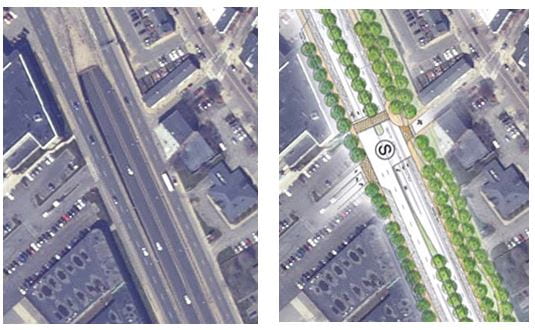
Since 2008, the City of Boston has been planning a project to convert Rutherford Avenue in Charlestown from a wide highway into a boulevard with a linear park, and to convert the oversized rotary and vehicle-oriented streets in Sullivan Square into a walkable urban grid suitable for transit oriented development. It’s a natural direction of change, since a parallel freeway has supplanted Rutherford Ave as the main traffic artery from the north, and because the demand for transit-oriented development at close-in former industrial sites like Sullivan Square is enormous.
In May/June, 2017, the Boston Transportation Department announced their planned design. To my dismay and that of many Charlestown residents, it falls far short of achieving the project’s objectives. Half of the linear park, from City Square to Bunker Hill Community College, has been eliminated because the designers have made the road so wide — almost as wide as it is today. In Sullivan Square, the new street grid they propose is not at all the pedestrian-friendly urban grid that was envisioned; it concentrates traffic into wide roads with pedestrian crossings that span 6 and sometimes 7 lanes.
The existing conditions on Rutherford Ave. are so deplorable that BTD can legitimately claim that its plan is an improvement. But is that the best we can do? This is a once-in-a-lifetime opportunity! Do we really have to give up on the original vision of turning Rutherford Ave. and Sullivan Square into people-oriented space?
Working with two graduate students, Amelian (Yanran) Chen and Yuhao Gu, I have created alternative designs that show that we can achieve the vision of a new greenway and a walkable grid while at the same time providing the traffic capacity needed to serve the traffic forecasted for 2040. There are designs for 2 sections of the corridor, with a 3rd anticipated shortly:
- A Pedestrian-Friendly One-Way Grid for Sullivan Square:
We find that in Sullivan Square, a one-way grid is far superior in every respect (pedestrians, motorists, development parcels) to the concentrated two-way grid plan the City is now persuing.
- Rutherford Ave @ Austin Street: A Surface Option that Works and the Failed Promise of the Underpass Option
Where Austin Street intersects Rutherford Ave., we find that compared to the underpass option the City is persuing (which consumes so much land that no space is left for a linear park, and yet at the same time does not have enough capacity for all traffic), there is a surface option with sufficient traffic capacity for all traffic movements that leaves 48 feet for a linear park. It offers better service for pedestrians, too.
- The southmost section (City Square to the Tobin Bridge on-ramp): Coming soon.
