
Centre St between Lagrange St and Esther Street (near Holy Name Circle) is West Roxbury’s main street, flanked by shops and businesses. It has 3 bus routes, a nearby commuter rail station, and several nearby schools that further contribute to pedestrian traffic.
For decades, Centre St was served by several streetcar lines (since converted to bus lines), and until the 1960’s had one traffc lane per direction and diagonal parking. That diagonal parking layout can still be seen today on a different stretch of Centre Street, near Weld Street.
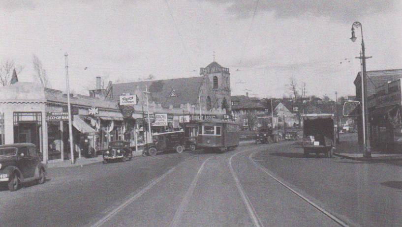
Centre Street got its present form in the 1960’s, when it was restriped with 4 lanes, making through traffic the dominant function. That’s a poor choice for an active commercial street. Those 4 lanes make it easy for cars to speed, and make it dangerous to cross the street. Over time, more and more traffic signals were added to improve crossing safety, to the point that now this stretch has 7 signalized intersections.
But it still isn’t safe – cars stop at a red light, and then speed on to the next, and this stretch still has 5 unsignalized crossings. This letter to City Council describes a pedestrian crash that, unfortunately, is all too predictable on a street like this – a car in the first lane slowed to let the pedestrian cross, but a speeding car in the next lane, screened by the car in the first lane, hit him. This crash type is so common it has a name – double threat.
Does Centre Street really need 4 lanes to carry its traffic? Traffic volume isn’t actually that high, because most traffic headed to or from Boston’s hub uses VFW Parkway, only 0.6 miles away. And on a 4-lane road, left turning cars often block the inside lane, so that much of the time only one channel of traffic gets through, anyway. That means that a single lane per direction, plus turn lanes to prevent blockage, can offer just as much capacity as a 4-lane road.
This post summarizes a study done by student Daisy (Huijie) Gao that demonstrates the feasibility of a “road diet,” reducing Centre Street to one through lane per direction plus turn lanes where needed. The reclaimed space is used to add crossing islands and protected bike lanes (cycle tracks). Here’s what a typical stretch of road near an intersection will look like: Centre St has one lane per direction, a median, a bus stop, and cycle tracks (green) behind the parking lane (blue). Our proposed design leaves the curbs unchanged, making it inexpensive to realize.
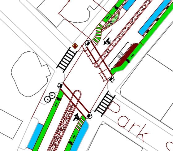
With only one lane per direction, speeding will be controlled – drivers will no longer see a wide, open road, and it takes only a single prudent driver to force all the cars following to go at a safe speed. The medians make crossings safe — one lane at a time, no double threat. Pedestrians no longer need traffic signals to cross the street, and so several signals can be removed, leaving in their place safe crossings with pedestrian islands where pedestrians have priority to cross with almost no delay. In the proposed design, only 3 traffic signals remain — at Belgrade, Corey, and Lagrange.
The impacts are as follow:
- Pedestrians: Crossing the street becomes safe, not just at signalized intersections, but everywhere.
- Pedestrians again: Crossing delay is greatly reduced- most pedestrians will wait less than 5 seconds to cross.
- Bicycles: Bicycling along Centre Street becomes immensely safer.
- General safety: Traffic speed will be reduced, and the fraction of cars going at high speed will be reduced drastically, because instead of seeing an empty, 4-lane road ahead of them, drivers will see a single lane squeezed between a parking lane and a median island.
- Parking: On-street parking is retained, but 22 parking spaces are lost to improve visibility at intersections. That’s about 1 parking space per block-face, and can be more than offset by better utilization of off-street parking.
- Motor vehicle traffic: delay is reduced by 28 s per vehicle, a reduction of 40%. What cars do now is race to the next red light. With a road diet, cars go slower, but there are fewer traffic signals; moreover, the signal cycles are shorter, meaning shorter red periods.
As this study shows, a road diet makes this street immensely safer for pedestrians. It becomes safe for bicycling – something urgently needed on this road that lacks a nearby parallel alternative. The road becomes genuinely child friendly – easy to cross, safe to ride a bike. And for motorized traffic? It actually lowers delay!
For more detail, read the full report: Centre St W Roxbury Road Diet Report, by Daisy (Huijie) Gao and Peter Furth. This study is based on a full set of counts made during a p.m. peak hour in 2017.
Here are the Intersection capacity and level of service reports made using Synchro.
The study also used the simulation software VISSIM to measure traffic delay along the entire corridor. (Video clip in preparation.)