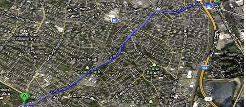
Columbia Road was originally envisioned as a link in Boston’s Emerald Necklace, a string of linear parks encircling Boston with paths for travel by foot, by carriage (later, car) and by horse (later, bicycle). It was to be a greenway link from Franklin Park to the Dorchester and South Boston beaches. Instead, it was laid out as nothing more than a busy 4-lane road. Graduate student Andy Leung studied the road’s physical space and traffic constraints, and found that there were two feasible ways of creating a greenway feel with safe bike routes while preserving the street’s traffic capacity and parking lanes.
Alternative A has a one-way cycle track on each side of the street. Here is the One -Way Cycle Track Plan. It creates paths for safe bicycling, but adds little in the way of green space.
Alternative B has a 2-way bike path along the north side of the road, flanked on both sides by a row of trees. This alternative creates a greenway arcade that offers people both a shaded bike path and a wide, shaded sidewalk. Here is the Two -Way Cycle Track Plan. The choice for the north side rather than south is mainly due to considerations at the endpoints, the Franklin Park entrance and Kosciusko Circle, where path continuation is far simpler on the north side than on the south.
Here is the project report, Columbia Road Greenway Design.
Until the road is rebuilt to be a permanent greenway, it could be a temporary greenway on summer Sundays by closing one side of it to motor traffic — an event called a Ciclovia or Open Streets. The challenge is to keep bus route 16 active in both directions in order to preserve access to neighborhoods and churches. The project report includes traffic plans for temporary Ciclovia closures as well as for the two cycle track alternatives.
